Why did Hurricane Otis 'explosively' intensify off Mexico? / Photo: - - NOAA/AFP
 Muslim women break taboos navigating east London's waterways

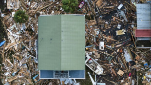
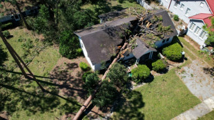 More than 60 dead from storm Helene as rescue, cleanup efforts grow

 Death toll from Hurricane John hits eight in Mexico
 SpaceX launches mission to return stranded astronauts

 SpaceX set to launch mission to return stranded astronauts

 Boeing strike grinds on as latest talks fail to reach agreement

 US ports brace for potential dockworkers strike

 US hurricane deaths rise to 44, fears of more 'catastrophic' flooding

 Europe en route for Moon with new simulator, says astronaut Pesquet

 Argentina judge orders dictionary to delete pejorative definition of 'Jewish'

 S.African woman turns 118, among the oldest in the world

 Barca fans barred from Champions League away game over racist banner

 Pope says Church must 'seek forgiveness' for child sexual abuse

 Cuts, cash, credit: China bids to jumpstart flagging economy

 Iran treads carefully, backing Hezbollah while avoiding war

 'Broken' news industry faces uncertain future

 Taken from mother by nuns, victim seeks answers as pope visits Belgium

 Hong Kong, Shanghai extend surge as China optimism boosts markets

 Drought reduces Amazon River in Colombia by as much as 90%: report

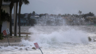 Florida bracing for 'unsurvivable' Hurricane Helene

 Chloe's see-through look may not be for Kamala Harris

 Macron, Trudeau pledge to work for 'decarbonized' economies

 China stimulus, tech optimism boost stock markets

 Macron meets Trudeau in Canada as both face political setbacks

 Chloe's see-through look may not be for Kamala

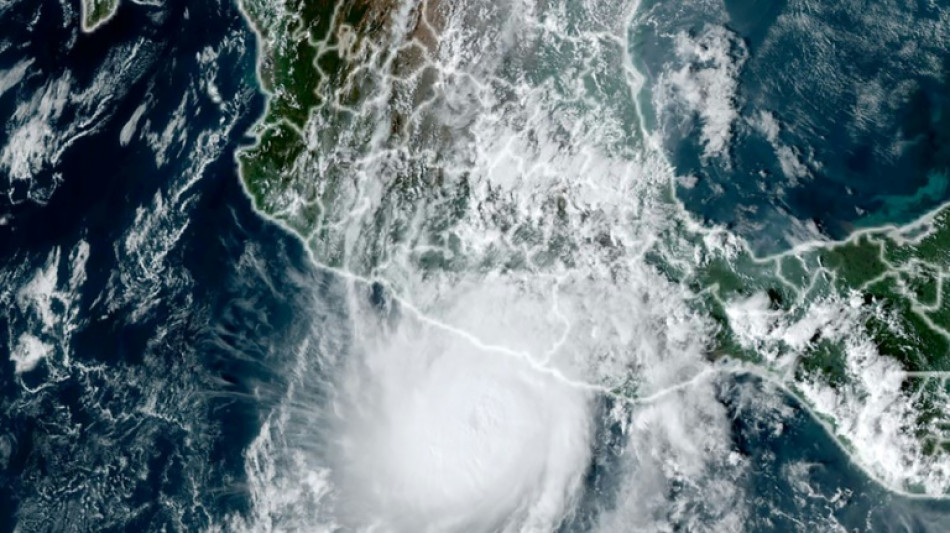
Hurricane Otis caused at least 27 deaths and major damage as it battered Mexico's beachside city of Acapulco as a scale-topping category 5 storm, according to officials.
The speed with which Otis rapidly intensified took the government and weather forecasters by surprise, leaving little time to issue warnings and prepare for its arrival.
Why was Otis so devastating?
"Otis's intensification was very exceptional. It was nearly record-breaking in some ways," said Michael Brennan, director of the Miami-based National Hurricane Center (NHC).
Within hours Otis strengthened from a tropical storm to the most powerful category of the five-step Saffir-Simpson scale before hitting land early Wednesday.
Otis "explosively intensified" with peak wind speeds increasing by 115 miles per hour over a 24-hour period, according to the NHC, which issues storm warnings and forecasts.
Otis was packing maximum sustained winds of 165 miles (265 kilometers) per hour when it hit the coast, the NHC said.
The World Meteorological Organization described the hurricane as "one of the most rapidly intensifying tropical cyclones on record," only exceeded in modern times by Hurricane Patricia in 2015.
Why did Otis intensify so quickly?
"Unfortunately Otis was able to take advantage of very favorable conditions" including warm deep ocean water and a conducive atmospheric environment, Brennan said.
"The storm was able to develop an inner core and a structure that allowed it to take advantage of those favorable conditions and environment in the ocean and the atmosphere to rapidly intensify," he said.
While hurricanes hit Mexico every year on both its Pacific and Atlantic coasts, usually between May and November, few make landfall as a Category 5.
"There are no hurricanes on record even close to this intensity for this part of Mexico," the NHC had said as Otis approached the Mexican coast, warning that a "nightmare scenario" was unfolding.
Is climate change to blame?
The water temperatures off the Mexican coast that Otis encountered were 30 to 31 degrees Celsius (86-88 degrees Fahrenheit), Brennan said.
"That may be a little bit warmer than usually but not tremendously so. That area is usually quite warm and has quite deep warm ocean water this time of year," he added.
"So it's hard to necessarily attribute that particular aspect of this to climate change or global warming. We'll have to look back and do some studies," Brennan said.
Will global warming bring more devastating storms like Otis?
Brennan said that "the science on that is not terribly well resolved at this point."
"There are some studies that suggest that rapid intensification is becoming more common in a warming climate," he said.
"We are very confident that the impacts of hurricanes from heavy rainfall, flooding and storm surge are worsening in a warming climate and will continue to worsen as the climate warms," he added.
That was due to rising sea levels leading to more dangerous storm surges and a warmer atmosphere holding more moisture, resulting in heavier rainfall, Brennan said.
The UN's Intergovernmental Panel on Climate Change said in 2021 that the proportion of particularly intense cyclones (categories 4 and 5) should increase by 10 percent compared to the pre-industrial era with a warming of +1.5 degrees Celsius, by 13 percent at +2C and by 30 percent at +4C.
As a result of sea-level rise and marine flooding, more than one billion people will live in coastal cities at risk by 2050, according to the IPCC.
X.Cheung--CPN